Far Western Kentucky — Including Union County — Now Under Rare MODERATE Risk for Severe Weather, Meaning Tornado Threat Has Increased
While chatting with Eyewitness News Chief Meteorologist Wayne Hart recently, he informed me that December is usually the month with the LEAST amount of concern with regards to severe weather threats.
SEVERE WEATHER THREATS IN DECEMBER
Well, by the 10-day mark of December 2021, not only will we have experienced TWO severe weather threats, the one the tri-state is under Friday night is the first of its level of severity in quite a long time. At the very beginning of the workweek, in the wee hours of Monday morning, we were paying attention to a strong cold front that brought multiple severe thunderstorms into the tri-state while tornadoes were largely relegated to southwestern Kentucky.
That event, by the way, occurred while we were under a level two SLIGHT risk for severe weather. The Friday night scenario, which continues to unfold, has western Kentucky and southern Indiana under a level three ENHANCED risk for severe weather. And now the National Weather Service has placed portions of far western Kentucky, including Union County under a rarely-issued MODERATE risk for severe weather. Here's what that means:
"An area where widespread severe weather with several tornadoes and/or numerous severe thunderstorms is likely, some of which should be intense. This risk is usually reserved for days with several supercells producing intense tornadoes and/or very large hail, or an intense squall line with widespread damaging winds."
FROM DAVIESS COUNTY EMERGENCY MANAGEMENT
Andy Ball, the director of the Daviess County Emergency Management Agency sent this regarding tonight's severe weather event:
"Currently, NWS-Paducah is estimating potentially severe thunderstorms for the Owensboro area between midnight and 4 AM.
Please take the threat of potential tornadoes and damaging winds late tonight seriously. More injuries and deaths occur during nighttime weather, and winter thunderstorms can be extremely unpredictable.
Everyone should have an alert notification which will wake them from sleep. The best method is to have a NOAA weather radio in your bedroom. Ensure it is plugged in, has back-up fresh batteries, and is programmed for your county. Weather radios are sold at Walgreens, CVS, Walmart, and Menards. Programming instructions and county codes can be found here: https://www.weather.gov/nwr/ and https://www.weather.gov/nwr/county_coverage?State=KY.
Stay current on weather, especially before you go to sleep. If you are able, remain awake during the storms to ensure you and your family can get to shelter quickly.
During a Tornado Warning:
- Move to the lowest level and to an interior room without windows, such as a closet or bathroom
- If you have a basement, this is your best option
- Cover your head and neck to protect yourself from debris
- If able to do so, wear shoes and clothing which will offer more protection from the weather and sharp objects
If you live in a mobile home, it may be best to sleep at a friend’s/family member’s house which can offer greater protection.
Do not rely on outdoor weather sirens as your means of notification. These are meant to alert people participating in outdoor activities."

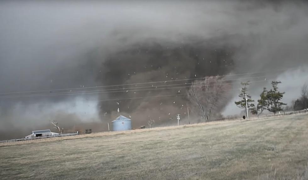
TORNADO THREAT FOR WESTERN KENTUCKY AND SOUTHERN INDIANA
According to the National Weather Service's Storm Prediction Center,
Severe thunderstorms capable of producing several tornadoes and
scattered to numerous damaging wind gusts are possible mainly Friday
evening and overnight from the lower/mid-Mississippi Valley into the
lower Ohio and Tennessee Valleys. A strong tornado is possible
overnight.
So once again, it looks like we will be dealing with the peak of this storm system/cold front in the overnight hours, just like last weekend. Consequently, the National Weather Service is urging everyone to have some way--like a weather radio--to be alerted since the main severe weather event is expected to be in the late evening into the overnight hours.
REMEMBERING THE JANUARY 2000 TORNADO
In the Owensboro area, we are approaching the 22nd anniversary of the January 3rd, 2000 tornado which ripped through the city destroying more than 100 structures--mostly homes--and causing severe damage to many others. So weather like this at this time of the year, while not very common, IS something we've seen before. And it has made residents of Daviess County and surrounding counties more vigilant when severe weather events are forecasted.
We will ALSO be vigilant and keep you updated as we get closer to the time of this severe weather event's arrival.
KEEP READING: What to do after a tornado strikes
LOOK: The most expensive weather and climate disasters in recent decades
KEEP READING: Get answers to 51 of the most frequently asked weather questions...
More From WOMI-AM