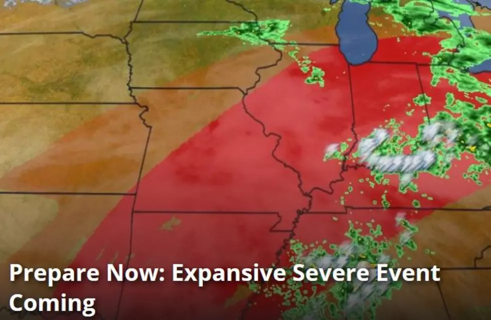
Tri-State Now Under MODERATE Risk For Severe Weather Tuesday Night Into Wednesday Morning
After a wild night of severe thunderstorms, a new system is headed our way with a MODERATE risk potential for later Tuesday night into Wednesday morning. Here's the latest from the National Weather Service in Paducah:
Locally heavy rain and lightning will dominate most of the storms early Tuesday morning. Thunderstorm coverage and intensity will decrease markedly through the morning and early afternoon hours today. Another round of strong to severe thunderstorms will work back into the area late this afternoon and through the evening. The threat for severe weather will continue along and ahead of a cold front that will make its way into the Quad State region by daybreak Wednesday. Damaging winds, hail, torrential rainfall, dangerous lightning, and even a few tornadoes will be possible with the storms tonight. It’s time to prepare for severe weather!!!
Keep your radio tuned to 92.5 WBKR and the Radio Pup app for the latest updates.
More From WOMI-AM

![Facebook Becomes Obsessed with Giraffe Giving Birth [Video]](http://townsquare.media/site/76/files/2017/02/A66.jpg?w=980&q=75)
![Enhanced Risk of Severe Weather Tuesday and Tuesday Night [Forecast]](http://townsquare.media/site/76/files/2017/02/A64.jpg?w=980&q=75)
![Thomas Rhett Presale Code [PHOTO]](http://townsquare.media/site/204/files/2014/11/458484190.jpg?w=980&q=75)
![Charlotte Got Her First Haircut Last Friday [VIDEO]](http://townsquare.media/site/76/files/2017/02/86bf1.jpg?w=980&q=75)
![Studio Keyboard Cord Has Familiar Words On It [PHOTOS]](http://townsquare.media/site/77/files/2017/02/IMG_2101.jpg?w=980&q=75)