Winter Storm Warning Has Been Issued for Western Kentucky and Southwestern Indiana
What we felt was inevitable on Monday has become a reality on Tuesday as the tri-state area is now under a winter storm warning. The easternmost counties in our area that are a part of the warning are Daviess, McLean, and Muhlenberg in Kentucky and Spencer and Pike Counties in Indiana.
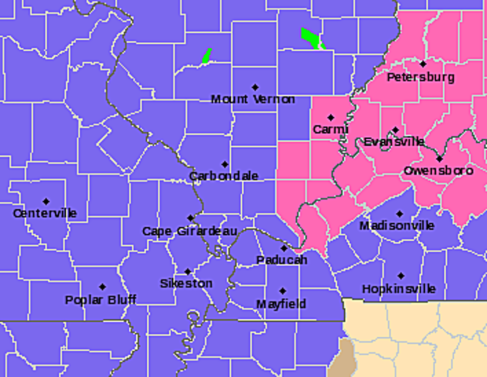
WINTER STORM WARNING
Here's what the National Weather Service is saying with regards to the warning, in effect from 6 AM Thursday to 6 AM Friday.
"WHAT...Heavy mixed precipitation is possible. Total snow and sleet accumulations of a trace to 2 inches, and ice accumulations of one-quarter inch with locally higher amounts possible.
WHERE...Portions of southwest Indiana, southeast Missouri, western Kentucky, and southern Illinois. This area is generally along and east of a line from Poplar Bluff and Cape Girardeau, Missouri to Marion and Albion, Illinois, stretching eastward to Mayfield and Henderson, Kentucky to Santa Claus, Indiana and Owensboro, Kentucky.
IMPACTS...Power outages and tree damage are likely due to the ice. Travel could be nearly impossible and should be avoided unless absolutely necessary. The hazardous conditions could impact those travelers during the morning or evening commutes, especially on Thursday."
2009 ICE STORM
In 2021, when we has another storm that produced some ice accumulations, we reflected on the 2009 ice storm. Whenever any winter weather system like this develops, I always ask Eyewitness News Chief Meteorologist for comparisons. Last year, he reminded me that we got one to two inches of ice in 2009 and dealt with widespread power outages. While the National Weather Service did include a warning about power outages with the coming storm, at the very least--I'm always looking for the silver lining in situations like this--the projected ice accumulations aren't as high as that.
We'll be following the storm's progress right along with you and keep you updated with any news as we get closer to the time of arrival. And hopefully, the news will get better. I'd take even a LITTLE better.
Tri-State Residents Recall 2009 Ice Storm Stories
LOOK: The most expensive weather and climate disasters in recent decades
KEEP READING: 9 Great Places for Sledding in Indiana & Kentucky
More From WOMI-AM


![Winter Storm Warning for Owensboro, Evansville and More [Forecast]](http://townsquare.media/site/76/files/2019/01/A36.jpg?w=980&q=75)